|
The Massive Montanore
Mine Proposal
Threatens Waters, Wildlife, and Wilderness
The Kootenai National
Forest and Montana Department of Environmental Quality
(DEQ) recently released a Supplemental Draft
Environmental Impact Statement (SDEIS) for the proposed
Montanore mine. The EIS can be found at:
http://www.fs.fed.us/nepa/nepa_project_exp.
php?project=11743 .
The EIS analyzes the
impacts of four different mine alternatives, including
the no-action (no mine) alternative, and five electrical
transmission line alternatives, also with a no-action
(no transmission line) alternative.
The permitting agencies
are now accepting public comments on the proposal. The
comment period closes on December 21, 2011.
Background and
Location:
The proposed Montanore
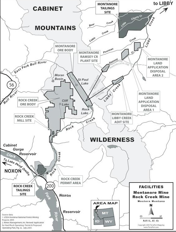
mine would be an underground copper/silver project with
an above ground tailings impoundment and processing
facilities constructed on lands in the Kootenai National
Forest 18 miles south of Libby, Montana. Similar to the
proposed Rock Creek mine, the Montanore mine would
extract ore from beneath the mountains, meadows, and
alpine lakes of the Cabinet Mountains Wilderness.
The
permit area, under the agencies preferred alternative,
Alternative 3, would
encompass 2,030 acres. In
addition, the proposed project would require the
construction of approximately 16 miles of high-voltage
electrical transmission line to power the mining
operations.
The permitting process for
the Montanore Project began in 1989 when Noranda
Minerals obtained a permit to construct an exploration
adit in the Libby Creek drainage just outside the
wilderness. In 1991, Noranda halted construction of
the 14,000-foot adit when the amount of nitrate
pollution generated from blasting operations degraded
Libby Creek. A state directive mandating the
construction of a water treatment facility, combined
with low metals prices led the company to abandon the
project.
Today, the company
currently pursuing a permit to construct the mine is
Mines Management, Inc. (MMI)/Montanore Minerals Corp.
The future of the Cabinet
Mountains Wilderness depends upon all of us.
Now is the time to get
involved by expressing your concerns about the proposed
Montanore mine. To view the Supplemental EIS, go to:
http://www.fs.fed.us/nepa/nepa_project_exp.php?project=11743
The Details:
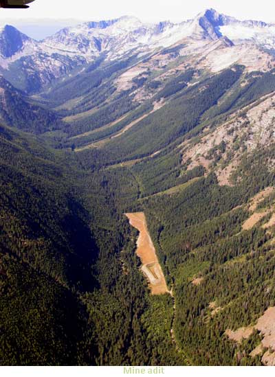
Four underground tunnels
or adits would be used to access and move the ore from
beneath the wilderness, or serve as a ventilation
source. An exploratory adit reaching the ore body
would be located along Libby Creek just outside the
wilderness. A ventilation adit would be constructed
above Rock Lake, an alpine lake located within the
wilderness.
Mine wastewater would be
treated and discharged to groundwater adjacent to Libby
Creek. The discharge would not meet current water
quality standards for nutrients and metals, but would be
allowed to degrade the quality of the receiving waters.
In 1992, at the request of Noranda Minerals, the state
issued an order that would
permit an increase in the concentration of certain
pollutants discharged to surface water and groundwater
above current water quality standards as defined by
Montanas 1971 nondegradation statute. The 19-year
order still stands despite changes in water quality
standards, best available technology, and new findings
related to the impacts of the mine.
Other discharges of mine
wastewater would include untreated water from the mine
cavity that would escape to groundwater through highly
fractured rock, and seepage from the tailings
impoundment to groundwater. Pollution from the mine
would require long-term monitoring and treatment.
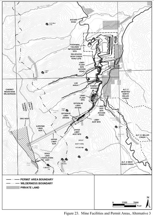
Under the permitting
agencies preferred alternative, 120 million tons of
mine tailings would be conveyed from the underground
mine via a pipeline to be stored in an impoundment
between Poorman Creek and Little Cherry Creek. The
tailings impoundment would require the construction of a
dam to contain the massive volume of mine tailings and
waste rock. The dam would be 320 feet high, 10,650 feet
long, and consume 675 acres of National Forest Land.
The surface area available
for the deposition of 120 million tons of tailings would
be insufficient, resulting in the need for a higher dam
that could affect the stability of the dam. The
agencies conservatively estimate the chance of a
catastrophic failure of this tailings impoundment to be
as high as 1%. The impacts from this failure would be
the loss of the entire Libby Creek Watershed. Toxic
sediment would fill Libby, Poorman, Bear, and Ramsey
Creeks, destroying the bull trout habitat in these
streams. The metal-laden sediment would eventually be
deposited into the Kootenai River potentially
threatening the habitat of bull trout and the extremely
rare white sturgeon, a species that has survived since
the time of the dinosaurs.
Seepage from the tailing
facility would have the potential to be acid generating
and the EIS states that effects on groundwater quality
beneath the impoundment are unknown.
Hydrological Impacts:
The area of the proposed mine
encompasses two major watersheds: the Clark Fork River
Drainage and the Kootenai River Drainage. One of
the greatest impacts from the mine would result from
massive dewatering of wilderness lakes and area streams
in both drainages as a result of the inflow of ground
water into the underground mine cavity and tunnels
(adits). While rain and snowmelt replenish some of the
water in area streams, most of the recharge comes from
groundwater. By diverting ground water into the
man-made mine void, the lakes and streams would be
deprived of the water critical to maintain their flows
and delicate water chemistry.
The EIS states that
groundwater drawdown and
related changes in stream flows will be greatest at the
end of mining and during the long post-closure phase.
Modeling of the hydrologic impacts predicts that
flows would be reduced in East Fork Rock Creek, Rock
Creek, East Fork Bull River, Libby Creek, Ramsey Creek
and Poorman Creek. Groundwater levels would not recover
until reaching a steady state 1,200 to 1,300 years after
mining ceased.
A significant portion of
the East Fork of Bull River and the East Fork of Rock
Creek would be completely dewatered for centuries. The
East Fork of Bull River provides habitat for most
productive bull trout population in the Lower Clark Fork
Bull Trout Recovery Area. This cold-water stream has
the deep pools the species requires to spawn and
survive. It is expected that after mine closure in
30 years, the East Fork of Bull River would lose 100% of
its ground water recharge, resulting in the
disappearance of this pristine wilderness stream. The
East Fork of Bull River would not reestablish most of
its pre-mining flows until approximately the year
3200. Bull trout would be long gone.
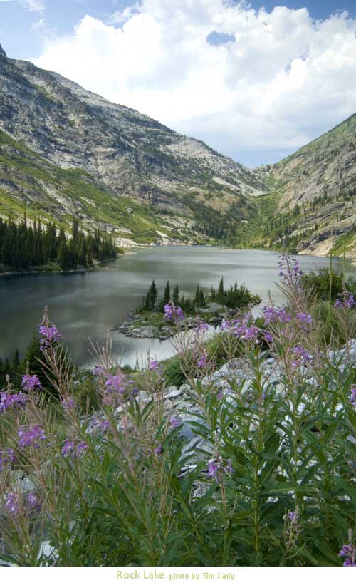
The East Fork of Rock
Creek flows from Rock Lake through the Rock Creek
Meadows until converging with the West Fork to form the
Main Stem of Rock Creek. Along the way, the creek and
the groundwater create wetlands that make Rock Creek
Meadows unique and productive habitat for wildlife and
fish. Bull trout and Westslope Cutthroat thrive here.
The proposed Montanore mine would transform the East
Fork of Rock Creek into a dry channel by diverting all
of the groundwater that currently flows to the stream.
Rock Creek Meadows would become parched in summer
resulting in the loss of the bull trout and westslope
cutthroat populations.
The main channel of Rock
Creek cannot survive without the significant water
contribution from the East Fork. The controversial and
legally contested Rock Creek mine already threatens Rock
Creek with the introduction of massive amounts of
sediment, and with heavy metals. Now, the struggling
stream and its fragile bull trout population face
threats from this additional mine. The Montanore
mine would dry the lower reaches of Rock Creek for long
periods of time. The waterless sections of the stream
would be expected to expand, rendering Rock Creek
virtually useless to migrating bull trout.
The volume of groundwater
flowing into Rock Lake and St. Paul Lake also would be
reduced. Some of the most drastic impacts would
be to Rock Lake, which sits almost on top of the ore
body that would be mined. The water table
surrounding Rock Lake would lowered by as much as 1,000
feet. Not only would groundwater recharge be cut off,
but the mine void would also siphon water from this
wilderness lake causing it to slowly drain. It would
be 1,000 years before groundwater flows would be
expected to return to pre-mining levels.
St. Paul Lake already
suffers from low water levels in very late summer.
During the dry summer months, groundwater would no
longer be available to help maintain its water levels.
The lake would depend solely on snowmelt and rain for
recharge. As a result, St. Paul Lake would be
transformed into a pond that begins to dry up shortly
after winter snowmelt disappears.
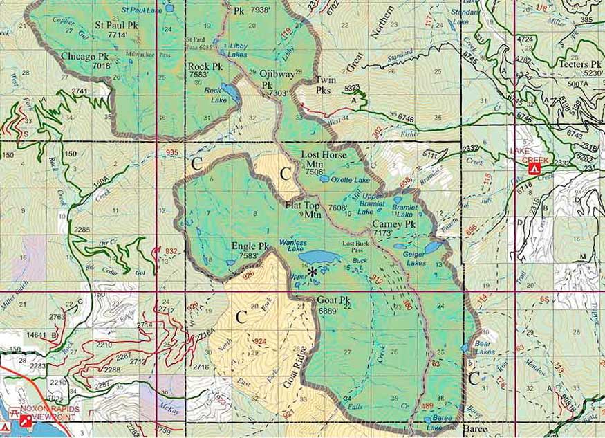
North of Rock Lake nested
between Elephant and Ojibway Peaks are the Libby Lakes.
These three pristine lakes sit virtually atop where the
proposed mine cavity would be located. The mining
company claims that these lakes are outside the region
of groundwater impacts because of their high elevation.
Others who dont have such a vested interest in the mine
see it differently. The loss of these remote and
incredibly pristine waters would be unacceptable.
The mined out cavity would
require almost 500-years to fill and the regions
groundwater would not reach pre-mining levels for almost
1,300 years. Until that time, places like Rock Lake and
the East Fork of Bull River would be shut off from the
water that that have always depended upon.
Fish and Wildlife
Impacts:
The proposed Montanore
Mine would result in significant impacts to three
threatened species and their habitatGrizzly Bear, Bull
Trout, and Canada Lynx.
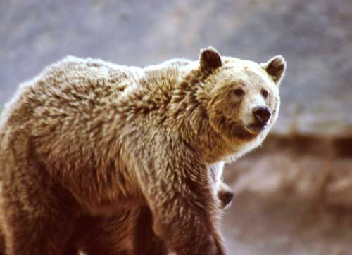
Grizzly Bear:
The proposed Montanore
mine would displace grizzly bears from approximately
25,000 acres of habitat. Industrial activities
associated with the mine that would drive grizzly bears
from their range include blasting of numerous mining
tunnels, road building, and construction of a mill
facility and tailings impoundment.
It would be impossible to
compensate or mitigate for this scale of habitat loss.
Grizzly bears would either be driven from the region
altogether, or begin using substandard habitat where
conflict with people would increase. Individuals that
crossed over the ridge line into the Rock Creek and Bull
River drainages would be faced with the prospect of
future mine development from the proposed Rock Creek
mine. The Rock Creek mine would displace grizzly bears
from an additional 7,000 acres, exacerbating habitat
loss. Direct habitat loss, disturbance, and increased
poaching would all raise the rate of mortality for this
already struggling population.
Under current habitat
conditions without either mine, grizzlies have not met
the criteria that the US Fish and Wildlife Service
believes is necessary for their recovery. The population
shows excessive female mortality and there is a 78%
probability of continued population decline. The
impacts from Montanore alone, and cumulatively with Rock
Creek, would likely drive the bear to extinction.
Bull Trout:
Native bull trout, a
species listed as threatened, are found in the streams
that would be dewatered by the mine. Bull trout require
clean, cold water with deep pools for spawning and
rearing. The drastic stream dewatering that is
predicted would impair bull trout spawning by degrading
or eliminating habitat. Significantly, the mine would
impact critical habitat that has been identified as
necessary for the recovery of the species. Designated
critical bull trout habitat is found in Libby Creek,
Rock Creek, and East Fork Bull River.
Introduction of sediment
into area streams from construction of roads and the
transmission line, as well as heavy metals from mine
effluent, would further degrade bull trout habitat.
Canada Lynx:
Lynx were listed as a threatened species in 2000. The
Kootenai National Forest is within a core lynx area.
The EIS largely dismisses impacts to Lynx, but
long-term losses of lynx
habitat are expected to occur as a direct consequence of
the Montanore mine. It is unknown how tolerant
lynx are to disturbance, but increased traffic and human
activity has the potential to restrict movement of this
carnivore. Construction activities would eliminate some
of the lynxs food base by reducing prey, and snow
compaction on roads and trails could increase
competition for food from other carnivores that would
normally be restricted by deep snow.
The risk of mortality from
vehicle collisions would increase considerably over
present levels, and easier access to lynx habitat would
raise the risk of incidental trapping mortality.
Other wildlife species
that would be substantially impacted from the mine
include Rocky Mountain Goat and Wolverine.
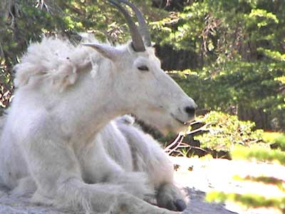
Mountain goats and
wolverines would be impacted primarily by disturbance.
It is anticipated that surface and underground blasting,
road building, transmission line construction, and
helicopter use would create stress for goats and lower
their reproductive success. The cumulative effects from
the Montanore mine, the Rock Creek mine, and other
proposed mines including the Wayup mine, would magnify
the impacts and could cause intolerable stress. To
escape the noise and human activities, goats would be
driven from the area, resulting in increased mortality
and the potential loss of the Rock Creek herd.
Wolverines would be driven
from denning habitat due to blasting and helicopter use
during construction of the adits and transmission line.
The elusive carnivore also would suffer increased
mortality as a result of human encroachment into
wolverine habitat. Wolverines are extremely rare, and
it is expected that they will be listed under the
Endangered Species Act in the near future.
Both Westslope Cutthroat
Trout and Interior Redband Trout would be affected by
loss of habitat from dewatering. Westslope occur in
many of the drainages in the project area.
Pure populations of interior
redband trout are found in Libby, Bear, Little Cherry
Creek, Poorman, and Ramsey creeks, and in the Fisher
River. Both species are listed as Sensitive Species.
Impacts to Wilderness:
The Kootenai National
Forest is 2.2 million acres; the 94,000-acre Cabinet
Mountains Wilderness is the only protected wilderness in
this forest.
The Montanore projects
mining operation would be located inside the Cabinet
Mountains Wilderness. As a result, impacts to
wilderness lakes are anticipated when the mine cavity
diverts the groundwater these lakes depend on for
recharge. Rock Lake, St. Paul Lake, and, quite
possibly, the high alpine chain of Libby Lakes would be
impacted. Wilderness streams and creeks would also be
subject to the effects of groundwater diversion,
including the East Fork of Bull River, which is
essential for the survival of the threatened bull trout
in the region.
Once the mine cavity
beneath the wilderness is created, the consequences
cannot be reversed. Subsidence or collapse of the
subsurface cavity and tunnels occurs frequently in the
industry. If that failure were to happen beneath the
wilderness, surface impacts could be expected.
Noise and visual impacts
would reach well into the Cabinet Mountains Wilderness.
Noise related impacts would be created by the blasting
of rock, heavy truck traffic, and the constant operation
of heavy equipment, generators, and ventilation fans.
Blasting of the evaluation adit would generate
noise louder than a jet engine. Under the agencys
preferred alternative (Alternative 3),
noise levels would increase
up to the ridge between Elephant Peak and Ojibway Peak.
The mine would create 24/7
industrial lighting, all well within visual range of the
wilderness, with significant impacts to the night sky.
Visual impacts to the wilderness would include a
massive tailings pile, 16 miles of power line
construction, the presence of industrial equipment and
facilities, and a ventilation adit adjacent to Rock
Lake.
Both the mine and
transmission line would diminish wilderness qualities
and reduce the opportunities for solitude. Visual
and noise impacts would continue through the 16-19 year
life of the mine. These impacts would not only be
significant for wildlife, but also would seriously
affect the wilderness experience sought by hikers,
wildlife enthusiasts, hunters and fishers.
The cumulative noise and visual impacts to the
Cabinet Mountains Wilderness from the Montanore and Rock
Creek mines would likely overlap and would be extreme,
driving out both wildlife and humans who seek the
solitude and wildness that is associated with
wilderness.
Impacts to air quality
would include cumulative impacts associated with the
neighboring Rock Creek mine. The wilderness has a Class
One Airshed, meriting the highest level of protection.
Air pollutants would include discharges of
particulates (PM10), nitric oxides, and sulfur dioxides.
Many species depend on the
Cabinet Mountains Wilderness for regional survival. The
grizzly bear, lynx, wolverine, and mountain goat will
suffer massive habitat degradation and increased
mortality. The loss of the opportunity to view these
species further diminishes the wilderness experience for
many people.
Cumulative Impacts:
The Montanore mine
singularly and in combination with other proposed mines,
especially the Rock Creek mine, would impact regional
water quality, threatened species, key fisheries and
wildlife populations, and the integrity of the Cabinet
Mountains Wilderness.
When considering impacts
of a proposed project, the US Forest Service is required
by law to take a hard look at the cumulative impacts of
multiple projects. In its analysis of the Montanore
mine, little consideration was given to cumulative
impacts, yet the Rock Creek and Montanore mines would be
in close proximity of each other. Montanores Rock Lake
Ore Body abuts the Rock Creek Ore Body and is separated
by a fault running through the mountain range. Mine
facilities and tailings piles would be only a few air
miles apart (See Map).
To see the big picture,
the permitting agencies must look at the cumulative and
additive impacts from both of these proposals and other
anticipated projects in the region.
.................................... |